

| << Chapter < Page | Chapter >> Page > |
GEOGRAPHY
Grade 5
MAP WORK
Module 4
DIFFERENT KINDS OF MAPS
1. Different kinds of maps
Every map tells its own story. Work in a group and look in the atlas for examples of the following kinds of maps:
political maps;
relief maps;
climatic maps;
vegetation maps;
population maps.
ACTIVITY:
SELECTING USEFUL INFORMATION AND USING IT
[LO 1.3]
Choose from the following options to complete the second column so the right kind of map is indicated:
| Kind of map | What story does it tell? | Possible options |
| Political maps | show countries’ borders | |
| Relief maps | where people live | |
| Climatic maps | mountains, valleys in an area | |
| Vegetation maps | the weather in an area | |
| Population maps | the plants in an area |
2. Use of colour on a map
A relief map indicates the different altitudes of regions. Regions with approximately the same altitude are indicated in the same colour. According to this physical relief of a country certain regions are also identified. We can therefore identify plains, mountains, rivers, swamps, dams, plateaux, etc.:
An explanation of a few:
COASTAL PLAIN - low-lying stretch of land close to the sea
PLATEAU - a reasonably flat landscape located high above sea level in the interior
PLAIN - flat, even stretch of land
MOUNTAINS - high-lying – a series of mountains are called a mountain range
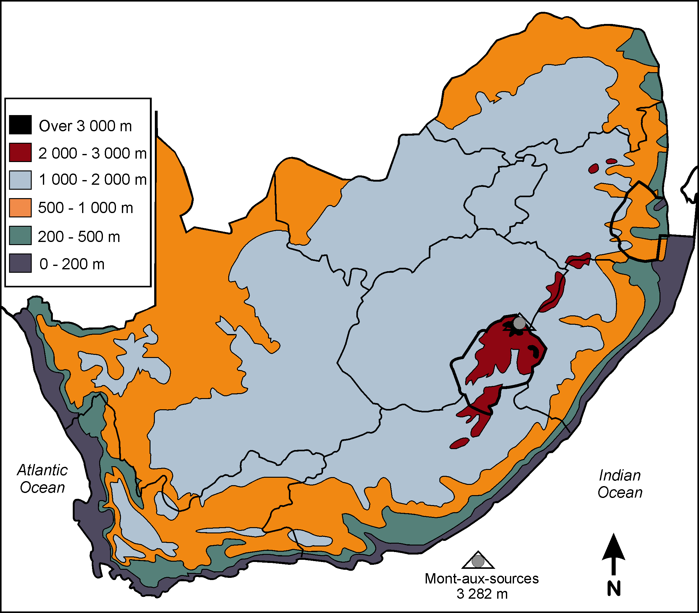
Observe the key that indicates specific altitudes. (The colours in brackets are simply an indication of the colour most widely used in atlases for regions of that particular altitude.)
If you look at a cross-section of South Africa, the profile will indicate the coastal plain on the western side that builds up to the plateau in the central region of the country, and then gradually descends down to the coastal plain on the east:

3. How do we use maps?
To use a map well, you must understand the following:
The heading or title
A map’s heading should always indicate the specific kind of information it contains. Look at any map in your atlas and you will see that it has a name at the top, e.g. AFRICA Political.
Direction
You must know which side of the map points NORTH. If you turn your map so that it points to true north, you have orientated your map. Remember that word?
If you don’t have a compass, there are a few ways to determine where TRUE north is:
By using your watch if it has an hour and minute hand.
The shadow stick method, by finding the shortest shadow during the day.
By doing a simple calculation at night by means of the constellation called the Southern Cross.
The easiest way is to determine where the sun rises and sets. The sun sets in the west and rises in the east. If you know where east and west are, it’s easy to find the others.
Assessment
LO 1
GEOGRAPHICAL ENQUIRY
The learner will be able to use enquiry skills to investigate geographical and environmental concepts and processes.
We know this when the learner:
with guidance, selects and uses sources of useful geographical information (including graphs, maps and fieldwork outside the classroom) [finds sources];
categorises information [works with sources];
draws sketch maps and/or plans from field observation and measurements [works with sources];
uses an index to find places on global atlas maps [works with sources];
demonstrates knowledge and understanding of the issue through projects, discussion, debate and charts [communicates the answer].

Notification Switch
Would you like to follow the 'Social sciences: geography grade 5' conversation and receive update notifications?

|
|

|
|

|
|

|
|

|
|

|
|

|
|

|
|

|
|

|