

| << Chapter < Page | Chapter >> Page > |
Study the following illustrations and answer the questions that follow:

1. What type of land use would you say is most prominent in this area?
2. Would you say that there has been a change in die original use of land in this area? Give a reason for your answer.
3. How did the activities impact on the natural resources of the environment?
4. Would you say that this is the ideal situation for urban development and land use?
Study the following illustration and answer the questions that follow:

1. Is the area depicted in the illustration, densely or sparsely populated? Motivate your answer.
2. Would you classify the area as rural or urban?
3. What type of land use is depicted in the illustration?
4. Would you consider the price of land in this area as cheap or expensive? Motivate your answer.
Answer the following questions:
1. Find out what percentage of the town/city where you live, or closest to where you live, is set aside for industrial purposes.
2. Find out what percentage (%) of the town/city is set aside for residential purposes.
3. Where would you expect to find the areas where the more wealthy people live? Is it close to the central business district or on the outskirts?
3. Migration of the population due to political policies
In South Africa we find a unique land use pattern, because of the political decisions of the past. If we look at an urban map of Port Elizabeth, we notice that certain neighbourhoods are inhabited by more than one population group. This is still the result of the policy of segregation and apartheid legislation before 1994. This policy determined that different population groups were to live in separate areas.
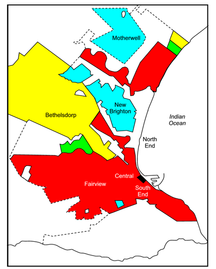
There was a time when Port Elizabeth’s South-End was inhabited by various population groups. However, when the National Party was in power, all residents were relocated to areas such as Malabar en New Brighton. Members of the Indian community were forced to settle in Malabar, and coloured people in New Brighton. This meant that certain people had to leave their homes and start anew. They had no choice as to where they preferred to live. Those belonging to a specific population group were obliged to move to an area allocated to people of their own culture.
Today we still suffer from the effects of this policy. Sometimes people were concentrated in a neighbourhood without a proper infrastructure like roads, electricity and housing. They could not afford to live anywhere else.
Study the following illustration and answer the questions that follow
1. What do you know about the sizes of homes in different neighbourhoods?
2. What neighbourhood would be most densely populated?
Notification Switch
Would you like to follow the 'Geography grade 8' conversation and receive update notifications?

|
|

|
|

|
|

|
|

|
|
|
|
|

|
|

|
|

|
|

|