

| << Chapter < Page | Chapter >> Page > |

Unfortunately for us, the motion along fault zones does not take place smoothly. The creeping motion of the plates against each other builds up stresses in the crust that are released in sudden, violent slippages that generate earthquakes. Because the average motion of the plates is constant, the longer the interval between earthquakes, the greater the stress and the more energy released when the surface finally moves.
For example, the part of the San Andreas Fault near the central California town of Parkfield has slipped every 25 years or so during the past century, moving an average of about 1 meter each time. In contrast, the average interval between major earthquakes in the Los Angeles region is about 150 years, and the average motion is about 7 meters. The last time the San Andreas fault slipped in this area was in 1857; tension has been building ever since, and sometime soon it is bound to be released. Sensitive instruments placed within the Los Angeles basin show that the basin is distorting and contracting in size as these tremendous pressures build up beneath the surface.
The difference in time from 1857 to 2047 is 190 y, or 1.9 centuries. Because only half the strain is released, this is equivalent to half the annual rate of motion. The total slippage comes to
0.5 × 5 m/century × 1.9 centuries = 4.75 m.
When two continental masses are moving on a collision course, they push against each other under great pressure. Earth buckles and folds, dragging some rock deep below the surface and raising other folds to heights of many kilometers. This is the way many, but not all, of the mountain ranges on Earth were formed. The Alps, for example, are a result of the African plate bumping into the Eurasian plate. As we will see, however, quite different processes produced the mountains on other planets.
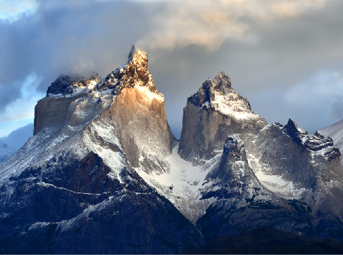
Once a mountain range is formed by upthrusting of the crust, its rocks are subject to erosion by water and ice. The sharp peaks and serrated edges have little to do with the forces that make the mountains initially. Instead, they result from the processes that tear down mountains. Ice is an especially effective sculptor of rock ( [link] ). In a world without moving ice or running water (such as the Moon or Mercury), mountains remain smooth and dull.
Volcanoes mark locations where lava rises to the surface. One example is mid ocean ridges, which are long undersea mountain ranges formed by lava rising from Earth’s mantle at plate boundaries. A second major kind of volcanic activity is associated with subduction zones, and volcanoes sometimes also appear in regions where continental plates are colliding. In each case, the volcanic activity gives us a way to sample some of the material from deeper within our planet.
Other volcanic activity occurs above mantle “hot spots”—areas far from plate boundaries where heat is nevertheless rising from the interior of Earth. One of the best-known hot spot is under the island of Hawaii, where it currently supplies the heat to maintain three active volcanoes, two on land and one under the ocean. The Hawaii hot spot has been active for at least 100 million years. As Earth’s plates have moved during that time, the hot spot has generated a 3500-kilometer-long chain of volcanic islands. The tallest Hawaiian volcanoes are among the largest individual mountains on Earth, more than 100 kilometers in diameter and rising 9 kilometers above the ocean floor. One of the Hawaiian volcanic mountains, the now-dormant Mauna Kea, has become one of the world’s great sites for doing astronomy.
The US Geological Service provides an interactive map of the famous “ring of fire,” which is the chain of volcanoes surrounding the Pacific Ocean, and shows the Hawaiian “hot spot” enclosed within.
Not all volcanic eruptions produce mountains. If lava flows rapidly from long cracks, it can spread out to form lava plains. The largest known terrestrial eruptions, such as those that produced the Snake River basalts in the northwestern United States or the Deccan plains in India, are of this type. Similar lava plains are found on the Moon and the other terrestrial planets.
Terrestrial rocks can be classified as igneous, sedimentary, or metamorphic. A fourth type, primitive rock, is not found on Earth. Our planet’s geology is dominated by plate tectonics, in which crustal plates move slowly in response to mantle convection. The surface expression of plate tectonics includes continental drift, recycling of the ocean floor, mountain building, rift zones, subduction zones, faults, earthquakes, and volcanic eruptions of lava from the interior.
Notification Switch
Would you like to follow the 'Astronomy' conversation and receive update notifications?

|
|

|
|

|
|
|
|

|
|

|
|

|
|

|
|

|
|

|