<< Chapter < Page Chapter >> Page >

The sun’s rays in summer and winter.

The Sun’s Rays in Summer and Winter. Panel (a), at left, illustrates how sunlight strikes the Earth’s surface in Summer. Five parallel yellow arrows, labeled “1 m2”, are drawn pointing downward at a 73-degree angle relative to the ground. Where the arrows strike the ground, a scale is drawn spanning the width of the arrows that reads “1.04 m2”. In panel (b), at right, illustrates how sunlight strikes the Earth’s surface in Winter. The five arrows are now drawn at 26-degrees relative to the ground. Where the arrows strike the ground, a scale is drawn spanning the width of the arrows that reads “2.24 m2”. Thus one square meter of sunlight falls on over twice the surface area in winter vs. summer.
(a) In summer, the Sun appears high in the sky and its rays hit Earth more directly, spreading out less. (b) In winter, the Sun is low in the sky and its rays spread out over a much wider area, becoming less effective at heating the ground.

The second effect has to do with the length of time the Sun spends above the horizon ( [link] ). Even if you’ve never thought about astronomy before, we’re sure you have observed that the hours of daylight increase in summer and decrease in winter. Let’s see why this happens.

The sun’s path in the sky for different seasons.

The Sun’s Path in the Sky for Different Seasons. In each of these three illustrations, a beige ellipse represents the ground and horizon of an observer standing in the center, and is surrounded by a semi-transparent sphere representing the sky. North is to the left, and west is at the bottom of the horizon ellipse. A yellow line, labeled “North celestial pole”, is drawn from the feet of the observer toward the upper left. A yellow dashed ellipse, labeled “Celestial equator”, is drawn on the sky sphere so that it touches the horizon at the points labeled “W” (west) and “E” (east) and is tilted to be perpendicular to the celestial pole. The left-most illustration shows the “Sun’s path June 21”, indicated by a faint yellow ellipse. The Sun rises and sets above the celestial equator. The central illustration shows the “Sun’s path March 21 and Sept. 21”. The Sun rises and sets along the celestial equator. Finally, the right-most illustration shows the “Sun’s path Dec. 21”, indicated by a faint yellow ellipse. The Sun rises and sets below the celestial equator.
On June 21, the Sun rises north of east and sets north of west. For observers in the Northern Hemisphere of Earth, the Sun spends about 15 hours above the horizon in the United States, meaning more hours of daylight. On December 21, the Sun rises south of east and sets south of west. It spends 9 hours above the horizon in the United States, which means fewer hours of daylight and more hours of night in northern lands (and a strong need for people to hold celebrations to cheer themselves up). On March 21 and September 21, the Sun spends equal amounts of time above and below the horizon in both hemispheres.

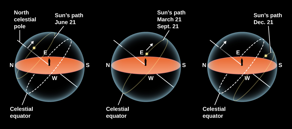
As we saw in Observing the Sky: The Birth of Astronomy , an equivalent way to look at our path around the Sun each year is to pretend that the Sun moves around Earth (on a circle called the ecliptic). Because Earth’s axis is tilted, the ecliptic is tilted by about 23.5° relative to the celestial equator (review [link] ). As a result, where we see the Sun in the sky changes as the year wears on.

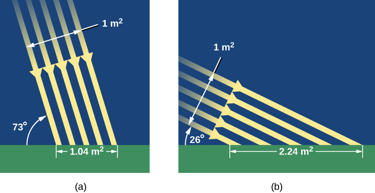
In June, the Sun is north of the celestial equator and spends more time with those who live in the Northern Hemisphere. It rises high in the sky and is above the horizon in the United States for as long as 15 hours. Thus, the Sun not only heats us with more direct rays, but it also has more time to do it each day. (Notice in [link] that the Northern Hemisphere’s gain is the Southern Hemisphere’s loss. There the June Sun is low in the sky, meaning fewer daylight hours. In Chile, for example, June is a colder, darker time of year.) In December, when the Sun is south of the celestial equator, the situation is reversed.

Let’s look at what the Sun’s illumination on Earth looks like at some specific dates of the year, when these effects are at their maximum. On or about June 21 (the date we who live in the Northern Hemisphere call the summer solstice or sometimes the first day of summer), the Sun shines down most directly upon the Northern Hemisphere of Earth. It appears about 23° north of the equator, and thus, on that date, it passes through the zenith of places on Earth that are at 23° N latitude. The situation is shown in detail in [link] . To a person at 23° N (near Hawaii, for example), the Sun is directly overhead at noon. This latitude, where the Sun can appear at the zenith at noon on the first day of summer, is called the Tropic of Cancer .

We also see in [link] that the Sun’s rays shine down all around the North Pole at the solstice . As Earth turns on its axis, the North Pole is continuously illuminated by the Sun; all places within 23° of the pole have sunshine for 24 hours. The Sun is as far north on this date as it can get; thus, 90° – 23° (or 67° N) is the southernmost latitude where the Sun can be seen for a full 24-hour period (sometimes called the “land of the midnight Sun”). That circle of latitude is called the Arctic Circle .

Get Jobilize Job Search Mobile App in your pocket Now!

Get it on Google Play Download on the App Store Now


Source:  OpenStax, Astronomy. OpenStax CNX. Apr 12, 2017 Download for free at http://cnx.org/content/col11992/1.13
Google Play and the Google Play logo are trademarks of Google Inc.

Notification Switch

Would you like to follow the 'Astronomy' conversation and receive update notifications?

Ask